 |
|
Note: Click on the thumbnails to access the bigger pictures!
Many thanks to Lenore Kennedy, who has translated the whole report!
At the beginning of June the decision was made. This year I would go on a bicycle vacation. I now had at my disposal a new Cannondale ST 800 randonneur (purchase date November 1990). After a period of fitting and measuring, I eventually found a good seat position, but now I had to choose a destination. A cycling vacation requires good very preparation, but some companies can make the hike from place to place more pleasant. One of these companies is Cycletours (CT). Your baggage is carried for you, meaning, in principle, that you don't have to worry about how much you take with you. Your transport to the starting point is also taken care of.
The company was chosen, now the destination. After weighing the pros and cons the far north was attracting me, and the choice fell on Sweden and especially Norway. The timing and the route were perfect - we would return just before the start of the mountain stages of the Tour de France; in June relatively few mosquitoes are around, and, especially in Sweden, there was a fair chance of good weather.
The flat part of Sweden gives you a good opportunity to do a bit of cycling before attacking the steep Norwegian mountains. The original trip started with a boat from Amsterdam to Goteborg, and ended with a boat from Bergen to Amsterdam. However, the Amsterdam-Bergen boat connection ceased this year, so after a call to CT I received the new route: by cyclebus to Denmark, then by boat to Goteborg, fewer days cycling in Sweden, more in (southern) Norway, back out of Oslo by boat to Denmark, then back to the Netherlands by cyclebus.
After some medical hassles, cycle-computer problems, and bad weather (which shot my whole training program to pieces), I rang CT on the Thursday because I had not as yet received my travel documents. I received them express post by noon the same day. Transport to the starting point was now different: by plane to Goteborg, and return by plane from Oslo to Schiphol. Travelling time was less, but the bike had to be transported by plane!
SATURDAY 22 JUNE 1991
After packing up and weighing my things in order to stay under
the 25 kg (initially 20kg) limit, I was taken to Schiphol. The
group was easily recognisable from the great variety of bicycles
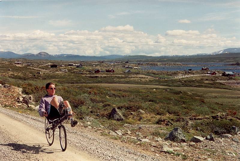
represented: Sebastian on a recumbent (M5 with grip shifts and
SPD pedals), Niels with an ATB (Merida Alu Shimano 500 Exage
fitted with semi-slicks), Petra on a grey Peugeot (just like my
old bike, with a Simplex derailleur and without mountain
gearing), John with a 1973 10 speed Raleigh with straight
handlebars, Wouter with a Van Tuyl racing bike, Henk with a nice
Pinarello, Ria with an aluminium Alan, Ed with a hybrid Koga
Myata Cityliner, Willem with a Raleigh racing bike, Arend with a
Batavus Champion Special with triple chainring, Rene with a Union
Randonneur, Pieter with a Gazelle Ventoux, and Cathy without a
bike (she hired one)
After an hour someone from CT turned up, but we had used the time to pack the bikes in boxes and styrofoam. On check-in we found that most of my travelling companions were badly overweight (up to as much as 50kg). I had a mere 23 kg as I was carrying close to the maximum weight allowance in my hand luggage. This led to some extra delay, which resulted in Cathy almost missing the plane. Because of this there was also no time to browse the duty-free shops, and we went straight to Customs. It was then we were told that the gas inflation bulbs for reinflating flat tyres were not allowed on the plane, because of the danger of explosion. Niels had to leave them behind, but could pick them up again on his return. After a good flight, with an intermediate landing and a stuffy two hour stop in Copenhagen, we arrived at Landvetter airfield in Goteborg. Here it transpired that unlucky Cathy's sleeping bag had not arrived (and it didn't catch us up until 4 days later in Torsby). Everything was shut at the airport because of the midsummer festival weekend, so I could not withdraw any money. Outside, the ride leaders Ronnie and Margriet were waiting. The bikes were loaded in to the KAV minibus (Kan Alles Vervoeren-Can Transport Everything), and we took the VIP taxi to the camping ground. Dark clouds moved across the sky and it began to rain softly. When we arrived at the camping ground a shelter had already been erected, so we didn't have to sit on the ground. CT looks after its customers well: there were wooden tables and benches covered by a plastic awning so that the cyclists were well protected from the rain, and from too much sun. During a break in the weather we quickly erected our tents and assembled the bikes.

SUNDAY 23 JUNE - stage 1 Goteborg-Uddevalla (109.2 km)
https://ridewithgps.com/routes/34948021
Around 7.30 I arose after a restless night, where I barely got 3 hours sleep. This was caused by Swedish revellers celebrating the midsummer festival, ducks choosing to sit and chatter on the flat space outside my tent, getting used to a new mattress, and the sun, which didn't set until around 3 am giving off too much light. I can easily imagine how W.F. Hermans was inspired to write his novel "Nooit meer slapen" (To sleep no more)...
I quickly washed, packed up my baggage packed and struck the tent, after which we fell on a solid cyclists' breakfast: muesli, crispbread, a selection of jams (jordbear, bringebear), yoghurt, milk, tea or coffee with or without whitener, eggs, solid crumbly rolls, a variety of toppings, and fruit (bananas for carbohydrates and oranges for the jolly little vitamins).
The route began in Goteborg. Many bicycle routes radiate from here and they are all marked with blue signs. These routes essentially follow the bicycle paths that are available in this heavily populated area. Alas, the CT people had only explored the route by car 3 weeks prior to our trip. The bicycle paths often don't run parallel to the main road, and there are many underpasses so you continually have to work out which direction to take next. So for the first 20 kilometers we were very busy just finding the right route. Luckily many of us had bicycle computers and the distances between the different points along the route were accurate. Yet it seems that not all computers are equally accurate, and some little errors had slipped in to the route description. From then on the route still ran to the south of the area for which I had a detailed map, so that the first 50 kilometers had to be cycled using only the route description. We cycled over a number of imposing bridges across the Gota Alv, the Nordre Alv, and the fjord area near Stenungsbund. The Tjornbron is one of the bridges that spans the waters of the Hakefjord. We took a rest on a terrace near the last bridge and ate our first Swedish pastries. Just as we started off again however, I noticed that my tyre was flat. The first flat tyre always generates a lot of interest, and many of my companions helped me to patch it. The route then followed a heavily used road (National road 160) and so we hatched the plan to leave this road quickly, and find an alternative route. This went up and down, and for a great part was unsealed, but was a great relief after riding in such a traffic jam. Just before we took this road I got my second flat. This was caused by a stone that pierced through the side of my tyre. My second spare blew to bits, and there I was with a flat tube and a busted tyre. Luckily Henk was nearby; he donated a tube, and a piece of canvas from John's toolkit temporarily mended the hole in my rear tyre. There is a great advantage in riding in company compared with riding alone - there is always someone who has just the right piece of equipment. Twenty kilometers before the end it began to rain gently. Everybody quickly donned their rain gear. After the last tunnel it started to rain buckets. Completely wet through we arrived at the Hastens camping site, rated three stars, but rather old and neglected. Nevertheless the hot shower did me good after such a first day of cycling, and two flat tyres.
MONDAY 24 JUNE - stage 2 Udevalla-Bengtsfors (120 km)
https://ridewithgps.com/routes/34948073
Today the rain had stopped, but the tent was still wet when being packed. In Munkedal we withdrew some money, and rode a short way in the wrong direction. Along a pleasant path through a thickly forested river valley we again came across the route that ran through Bohuslan and Dalsland. This region is undulating and is used mostly for cattle-raising. We made our first purchases in a big supermarket in the hamlet of Hedekas. We were quickly confronted by the high prices, and as true Dutchmen, we bought bread rolls from Tilbund: on special. The good old bread rolls went down like cake.
At Ed we made another "Coffee and cake" stop. The landscape changed slowly, we cycled through vast forests with a lot of water on the sloping paths. In the last part of the route there were a few longish climbs, and finally, after a dry day, we finished at a nice camping site in Bengtfors. Ronnie had found a bicycle shop in Uddevalla that had my size rear tyre in stock (27"). It was a wide tyre (35mm), and I would need it in the following days. In the evening we strolled along the lake shore, but alas, all roads led back to the asphalt, so we soon turned back.
TUESDAY 25 JUNE - stage 3 Bengtfors-Arvika (145 km)
https://ridewithgps.com/routes/34948126
Today Ed, Niels, Sebastiaan, Pieter and I planned to visit some rock drawings to the south of Bengtfors. We therefore had to ride about an extra 40 kilometers, but we were quite prepared to do it. The whole day was dry and reasonably sunny. At Hogsbyn we found about 10 stone pictures (Hallristningar), which were carved into the stone in prehistoric times. Now they have been picked out in red paint. There were many images to be seen, such as hands (some with six fingers), sheep, deer, dolls, and other graffiti like things. After we had partaken of a cup of coffee and fresh apple cake with the caretaker, we climbed on our bikes and resumed our route. This ran through a splendid area with many unsealed paths, thick woods, and short climbs lasting one kilometer max. In Edelkog we cycled past an open air play being performed in medieval costumes. To the north of that place we rode up the Baljasen, which, at 301 meters, is the highest hill in Dalsland, and where we enjoyed a broad vista.
Back under way traffic signs warned us to beware of crossing elands, and shortly before the hamlet of Bergane we came upon one as it was crossing over the road. Unfortunately my camera was not close at hand, and she quickly disappeared. At Ommeln we were back on the stipulated route. Near Svanskog Niels twisted his chain; Pieter's chain breaker did wonders for that, but a bit later Pieter snapped his brake cable. We could therefore no longer take a slightly longer route (via a ferry and unsealed), so we headed straight for the camping ground.
WEDNESDAY 26 JUNE - rest day in Arvika
It rained the whole day, but luckily the camping ground was
provided with a TV room with a heater. Nothing came of a planned
cycle through a nature area, but the time was used to advantage
to repair a bag that had been damaged in the aeroplane, reading,
and writing postcard after postcard. Arend had some trouble with
his knee and went to see a doctor. At midday we took a bus in to
Arvika and ate at a pizzeria. The village is known for its
sculpture and there is one of a cyclist we could really
appreciate. Pieter, Wouter, Ed and I chose to ride shanks's pony
rather than catch the bus, and we walked back to the camping area
(4 km) through an open air museum with old houses and windmills.
THURSDAY 27 JUNE - stage 4 Arvika-Torsby (98 km)
https://ridewithgps.com/routes/34948155
The day started off dry. It began to rain after a short stop at the Gunnern. I removed my sunglasses (used to discourage flies) because visibility was practically nil. On a long unpaved stretch (20 km) it rained harder and harder, which really made me want to move on. The unpaved road went up and down, cutting across the thickly wooded landscape. Without any breaks I rode to the camping site in company with Cathy and Petra.
It was dry when we arrived, so we quickly laid our wet gear out to dry. The camp ground was set up just like the other one, with a TV room with a small heater and WC, that we could use just for ourselves. Niels, Rene, Sebastiaan and Wouter chose to stay in a stuga- a simple hut with cooking facilities and two bunks.
FRIDAY 28 JUNE - stage 5 Torsby-Kongsvinger (98 km)
https://ridewithgps.com/routes/34948182
Today we said goodbye to Sweden and said hello to Norway.
Sweden is known for its dry climate, but the first few days were
wetter than expected. A well known saying in the first week is
that the weather will change…
The weather caused us to look towards the notorious mountains and
fjords of Norway with fear and trembling. Much of their splendour
would be lost and the roads would display their nasty side.
Before the border we stopped at a little shop in Ostmark and
attempted to change our Swedish krones there. Before we said bye
bye to Sweden we rode back a bit to a copper mine. This was
comprised of a few old huts by a deep river valley, with two
pits. We had no time to venture deep into the workings so
continued on our way. By the hamlet of Lundersaeter we took a
left up a very steep little path (about 10% for 1 km). Luckily it
didn't last too long, but I had to engage my smallest chain ring
(28 tooth) for the first time. After this climb we descended over
steep unpaved roads, where some of my companions didn't dare to
brake, or else kept their eyes shut tight! This descent was not
completely without danger, as Sebastiaan came a cropper off his
recumbent. Luckily he only received a few grazes. At the border
we took a few photos and stopped for a bite to eat. We all
covered the remaining kilometers quickly and arrived at the
campsite around 3 o'clock.
SATURDAY 29 JUNE - stage 6 Kongsvinger-Moelv (137 km)
https://ridewithgps.com/routes/34948196
The weather today was really bad, it rained cats and dogs nearly all day. We rode together 'en groupe' for the first 60 km. It was really hard work riding at the head of the pack, but someone had to do it. Near an army training camp we took shelter to eat a bread roll. The Goretex lining in my jacket didn't work as well as I'd hoped: I was wet, shivering, and cold. Standing still in the breaks is no good for the circulation. The next kilometers were just as wet and required a lot of effort. We cycled along the Mjosa lake, but I can't say if it was a good view or not. The way ran straight through Hamar by the side of a train museum and a camping ground (I wish they had reserved a spot there!), via a residential area on a hill. Then followed a pretty stretch along a narrow, unpaved, muddy path, and a section that was forbidden to cyclists. The last 15 kilometers seemed flat, but wasn't, and there were no descents to sweeten our eventual arrival in Moelv. Everybody, all our clothes and all our tents were wet, so we traipsed off to four heated hyttes and tried to get our tents dried out a bit. Here we heard the news that Arend was going to leave us. His dicky knee had forced him to abandon his trip, and he would be taken to the airport in Oslo the following day.
SUNDAY 30 JUNE - rest day in Moelv
The huts guaranteed us a very good night's rest, the night
finally became truly dark, and we slept in very comfortable
bunks. The day passed peacefully and was a real rest day as well
as a washing day. Before everything was clean and dry the day was
almost gone. Around midday we took a stroll to the distant Mjosa
lake and the small village of Moelv. This consists of one street
with a few shops and a Chinese restaurant. We bought an icecream
(the weather had improved!) and decided to dine on the leftovers
from the previous day. A few of the others went to the Chinese,
and returned in the evening, hungry. Meals in Norway do not make
allowances for cyclists, even those who haven't cycled for a
whole day.
Throughout the day the route of another famous tour, Den Store Strykeproven, passed right by the campground. This cycle tour attracts ten thousand participants who must travel 540 kilometers in 48 hours. We kept seeing big groups go past, and the remarkable thing was the good shape they were in considering they were only 130 km from the finish line. We finished the day with a half liter of beer for 38 NK (about 12 florins)
MONDAY 1 JULY - stage 7 Moelv-Skabu (125 km)
https://ridewithgps.com/routes/34948237
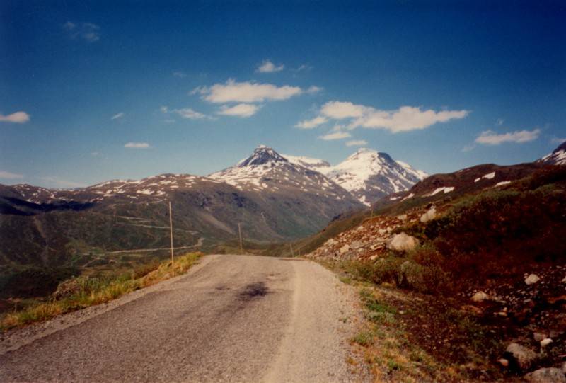
Today we began our great trial of strength: the Norwegian mountains. Before we took off we withdrew money from the post office in Moelv. For a few kilometers the way looks deceptively flat then dives down in to Lillehamar. This was the city where the 1994 Winter Olympics were held. There was no time to get to know the place better because some really stiff kilometers were still awaiting us. This is the first "mountain" stage through the land of Peer Gynt, a legendary character who met with his adventures in this region.
We followed the Gausdal and the Espedal. The landscape changed slowly: sometimes the mountains exhibited a white crown, there were many waterfalls, and the roads became much quieter. The weather was changing too: it stayed dry and grew warmer.
At the start of the Espedal we had to expend considerable effort on the pedals, and our breath was cut short by a horribly steep piece of road that went straight up into the sky. Some participants had decided not to use mountain gearings, and were forced to walk to the top. After the bend the slope flattened out a bit, and when we stood on the top, puffing, we had a grand view over our destination in the days to come: the mountains. Underway again we came across a large group of 'skilers'. On skis with wheels they were preparing themselves for the winter season.
The last inclines were the biggest strain, most certainly because they rose steeply. A few kilometers before the campsite the path climbed for three kilometers with an average incline of ten percent. One by one we all arrived exhausted at the peaceful, elevated campsite (900 meters). Time and again Cycletours knew where to find the most beautiful places. Except for one other guest we were the only ones at the campground, and the splendid view was thrown in for free (well, yes, you did have to sweat a bit).
TUESDAY 2 JULY - stage 8 Skabu-Grindaheim (116 km)
https://ridewithgps.com/routes/34948291
Today we would traverse the eastern flank of the Jotunheimen,
the highest mountain range in Scandinavia. Before we set off into
this area we visited an old wooden church in the village. A
little old woman appeared with an enormous key and stuck it into
a no less imposing lock. After visiting the church we headed our
bikes in the direction of the Jotunheimen.
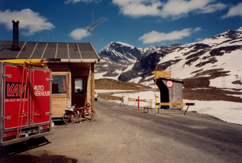
The Jotunheimvegen was the first toll road that we had
encountered along the route. In Norway, many toll roads are not
expressways, bridges or long tunnels, but are badly paved goat
tracks. Toll roads of this type demand a contribution from the
motorised users of the road. As a cyclist you don't have to pay
any toll, but you pay it figuratively anyway. The roads are so
bad that anything that can shake loose will, and gravel often
forces the cyclist to walk even if you haven't fallen off. In the
Cycletours brochure they mentioned the need for multipurpose
shoes (cycle plus walking). These shoes would surely be put to
good use on the tollways, because everyone had to walk for a
short or long period, and we all ended up talking about a
tramping-cycling holiday. To make matters worse a truck was
spreading fresh gravel right under our noses, so we were
continually riding like a steamroller…
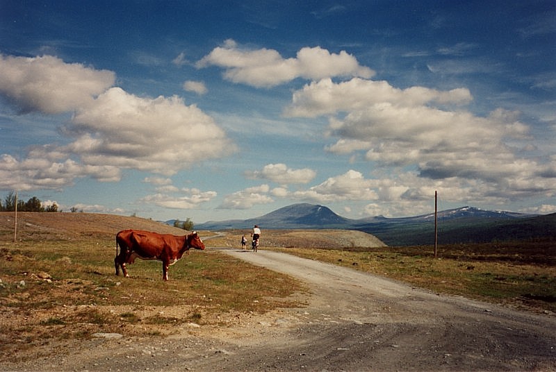
Up on the high plain there were a lot of cattle running free. Several cows, sheep and goats were particularly uninterested in the passers by, they must see cyclists often. You must take great care, as during the descents they could be standing in the middle of the road.
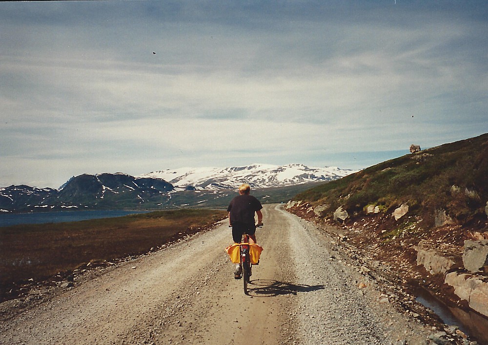
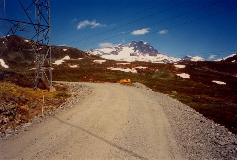
On the gravel road Cathy broke her chain, and Pieter's chain breaker again performed wonders. We even had time to enjoy the view, and Rene wanted to take a photo of some goats. They didn’t like that and started coming towards him. A few seconds later the whole road was covered with the animals, who tried to eat everything in sight, but even for them a bicycle was too tough. On the tollway we encountered a fully loaded German ATBer; he was dressed very warmly (winterjacket, beanie, long pants) in marked contrast to us in our summer gear: shorts and T-shirt. The highest point on the road is 1200m, and there was enough snow lying around to make a few snowballs. Above, on the plateau, it was still really windy, but the cold is not that bad. At the end of the tollway, after about 50 km, we treated ourselves to a mug of coffee and an extremely delicious assortment of apple pastries in the Bigdin Hoyfjellhotell. The unsealed road had not done Cathy's wrist any good . She stayed behind at the hotel and was collected in the KAV van. A doctor said later that she had damaged a tendon and it had to be plastered, so that meant she couldn't ride for a few days. We continued on our way to Grindaheim with a lovely long descent on new asphalt, where it was possible to reach speeds exceeding 50 kph. The temperature rose above 25 degrees C, so that the last kilometers had to be cooled off with icecream. After a steep climb and an unsealed descent we cycled along the Vangmjosa to reach our destination of Grindaheim.
Petra was picked up late in the evening: she has missed a turning and had got lost. Henk complained loudly about the promised well prepared compressed red loam, that was now covered in fresh gravel. At the campground Niels wrecked his arm and he couldn't ride the next day either. There was more bad news at the campground. All the comforts were provided at the site, but these couldn't be used after 9 pm! After a hard day we therefore crawled under the canvas early.
WEDNESDAY 3 JULY - stage 9 Grindaheim-Luster
(120km)
https://ridewithgps.com/routes/34948308
Today I was forced out of my tent early by the
burning heat of the sun. This held good promise for the day to
come. It was going to be a hot day, but also a difficult one, so
we got underway extra early. First we followed the Vangmjosa for
a few kilometres. After we crossed over the stream the path began
to climb slowly. After 22 k we hung a right and passed by a nice
waterfall. Alas, I was comfortable in my rhythm and decided to
cycle on and not stop to take a photograph. The following
kilometers rose even steeper (7%), and finally we arrived at a
small mountain lake (Tyin lake). After climbing from 466 to 1117
m we had a fabulous view of the snow covered peaks. We cycled
beside the lake for a few kilometers then over part of the
plateau, where there was still a lot of snow lying around.
Following that we were rewarded with a breathtaking descent
through many short unlit tunnels. It's cold in the tunnels, and
melting snow drips down the walls. Also they were still working
on the road, so that you came plummeting down at a speed of 50kph
then had to jam the brakes full on. You couldn't go any faster
than that because there were a large number of bends.
Suddenly the small fjord village of Ovre Ardal came in to view,
and shortly afterwards we found ourselves in that small place. We
had a long break here with coffee, orange juice, and sweet rolls.
Well fuelled, we cycled through the village and suddenly we found ourselves at the end of the valley. A narrow path led upwards, and it was just as well a signpost pointed towards Turtago, otherwise you would think it led to the yard of one of the villagers. The path immediately swung upwards (more than 10%) with horribly steep hairpin bends. I had to call on my lowest gear (28 x 30), and try as much as possible to take the bends on the outside. Sweat poured from my forehead, and I was immediately sorry I had covered it in sun tan oil. With burning eyes and a swarm of flies under my sun glasses, in my ears and now and then in my mouth, I cycled upwards at a speed fluctuating between 8 and 12 kilometers per hour. With my cap I tried to dislodge the nuisances, but it didn't help much. Sprinting was effective for a short time, but I couldn't do that for the whole 20 km stretch. Luckily the steepest part of the route was over in 10 kilometers, but then the path dipped for a few kilometers. I was temporarily rid of the flies, the wind cooled me down, but I lost precious meters in altitude! I stopped to take a photo of a nice waterfall, then stepped on the pedals quick smart because the pests were quickly gathering around me again. Suddenly the good asphalt became a gravel road. The old asphalted road could still be seen, but it ran out in a few places, only to continue thirty or forty meters higher up. The advantage of a gravel road is that its not so steep, but you have a hard time staying on your bike. Time and again my rear wheel slipped sideways, and I balanced my way forward at the mighty pace of 6 kph. Luckily I had a wide rear tyre, but many of the other riders were forced to walk. I often thought I had reached the top, but then saw that beyond the expected summit there was yet another rise to get over. Ronnie, who often rode with us for a bit, had to ride the whole stage today, as the KAV bus was full. Margriet drove the invalids van, and Niels and Cathy sat next to her. It was evident that Ronnie was an amateur racer for a short time, for he disappeared out of sight, and we wouldn't see him again until we reached the campsite. Finally the road became asphalt again, and by a small tollhouse I stopped and waited for the others.
The amount of snow lying around at this height was striking.
It was even stranger that the sheep wandering around the place
were obviously not the least bothered by the cold. After a roll
and a rest we all climbed back on our bikes. The road still rose
slightly, but it was reasonably well surfaced. Suddenly we hit a
descent. It was as if the road had been cut through a snowfield,
and the two meter high snow walls produced an eerie effect. The
descent came to an abrupt halt, and again we had to climb very
steeply (15%) to the pinnacle of the whole vacation:1300 meters.
My legs were screaming out to stop and walk, but that required
much more energy. Luckily this section didn't last for long, and
the road descended in a series of sweeping hairpin bends. Above
us we saw a number of hang gliders falling out of the sky. It is
odd to see such bright colours in the sky after toiling up such a
difficult mountain in the high peaks. After a left turn at a
T-junction near the Turtago sport hotel, the asphalt became very
nice, and wide. A hay wagon was travelling in front of me, alas,
so I couldn't cut loose on the downhill. After six and a half
hours of solid cycling we stopped for an icecream in the little
town of Skjolden before setting out on the last ten kilometers
along the fjord towards Luster. Salt had leached into my shirt,
and we drank bouillon to try to bring our salt levels back to
normal. After that, magnums and other icecreams provided the
necessary cooling off.
John, Henk, and Ria struck out on the climb up to Turtago. Henk
had at least a million cuts in his tyre. Petra broke her
derailleur, and in so doing couldn't complete the last few
kilometers of the descent. They were both picked up by the KAV
bus in the afternoon.
THURSDAY 4 JULY - Rest day in Luster
After a very tiring day, today was a peaceful rest day by the
fjord. I had already planned to cycle to one of the glaciers
today. This would have been a round trip of 110 kilometers, and
that would really have been too much of a good thing after the
previous day. Also, I didn't know exactly how difficult the
following days would be, so for a change I went for a few hours'
walk. The track ran right by a farm, and after taking a few
photos, I returned the same way. The village of Luster didn't
look like much and consisted of two supermarkets and a post
office. As well as this there was an old church, an idle ski lift
and two waterfalls, that are the village landmarks.
In the evening we had a barbecue of roasted chicken followed by something that looked like smoked reindeer meat but later it turned out to be fishcakes. The 'nearby' pub we went looking for after our meal proved to be ten kilometers away, so we crawled into our sleeping bags early.
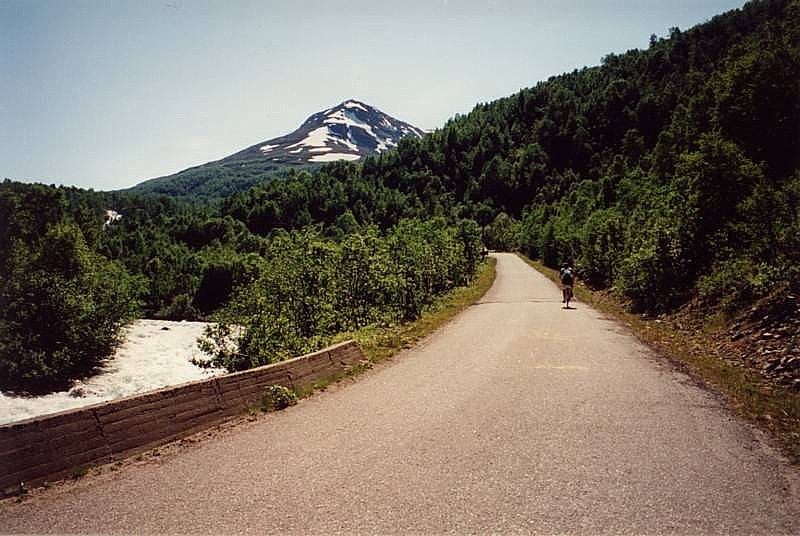
FRIDAY 5 JULY - stage 10 Luster-Aurland (114km)
https://ridewithgps.com/routes/34948385
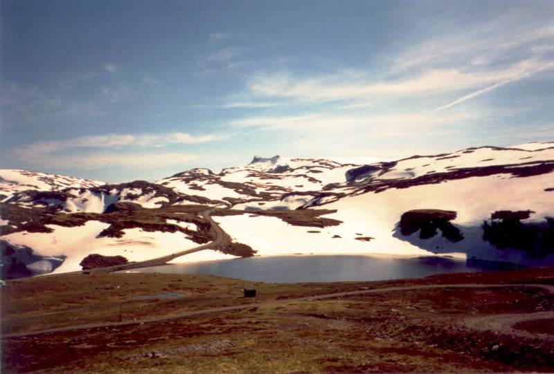
We left Luster around 9 am. For the first few kilometers we rode along the fjord. After ten kilometers the road slowly climbed up to eventually descent through the forest towards Hafslo which lies on the Veitastrondvatnet. We rode by Sognedal over a branch of the fjord, came across an open air museum and a very old "stavkirke" and collided with the end of the path at Kaupanger. The route continued on the opposite bank so we had to be ferried across on the punt. After a group photo we climbed on our bikes again, and after a few kilometers we began to climb out of the fjord. This climb was not particularly hard, but the heat and the flies made it very unpleasant. After stopping for a bit to take a photo and to cool down in a small stream, hundreds of flies came up to keep me company. As I didn't find this so friendly I sprinted upwards hard for about ten meters and managed to leave the majority of my passengers behind. Some meters later a few of them returned, so that now and then I breathed in a protein-rich gulp of air. By a small lake, that appeared in the middle of the snow, I dismounted to get some better nutrition inside me, and to take some photos. Just before the lake I had overtaken a loaded up Danish cyclist, who was having even more trouble with this pass. He wove from left to right to make the gradient less steep, but he was making hardly any headway.
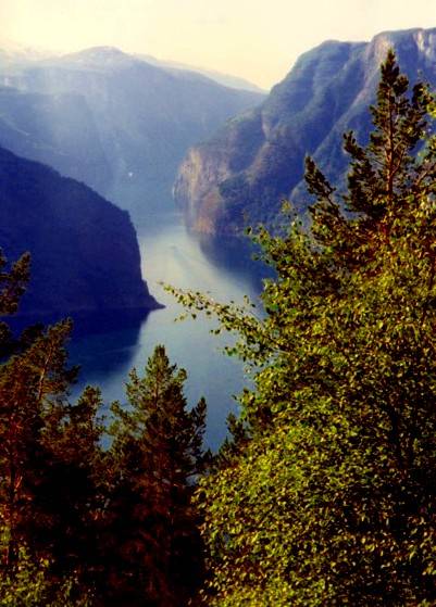
The major part of the climb to 1306 meters through the Hornadalen was over, there now followed ten or so kilometers through a snow covered plateau. Cycling through the snow fields and between the high snow walls on this stretch was a crazy but cold undertaking. It seemed just like a deep freeze, so I quickly donned my rainjacket. This also helped against the wind on the lovely panoramic descent. Suddenly, after a bend, we again got a really fantastic view of the perpendicular walls of the fjord, at a place where a special lookout had been built. The last kilometers to the Aurland square went by quickly, and an icecream took care of the sorely needed cooling down.
SATURDAY 6 JULY - stage 11 Aurland-Geilo (111 km)
https://ridewithgps.com/routes/34948405
Today it was still cold because the high fjords and the narrow
valleys don't admit much sunlight. Climbing warmed thing up, but
today there was something that really sent shivers down my spine:
tunnels. In the first 40 kilometers through the lovely Aurland
valley (the nicest in Norway according to Reizen magazine) there
are ten pitch black tunnels. The first is only short, and the
second is lit, but then follow three tunnels that are long, unlit
and winding, but climb upwards nevertheless. I had the use of a
dynamo with a halogen lamp, but I could see almost nothing (in
the first tunnel that was because I was still wearing my
sunglasses). Only the red light of the rider in front of me
showed that there was no bend ahead. The annoying thing is,
however, that if you ride less than ten kilometers per hour you
don't produce enough power to run the dynamo. I scraped in a bend
along the edge and practically stopped for a time. From behind
and in front I could hear cyclists sending out their signals like
bats:
"help, I've come to a standstill, shit my light's not
working any more, bump, hole, look out ..."
After the rising tunnels there luckily followed a couple of flat, or even descending tunnels. With some cyclists these are not that bad, but I would still always prefer a stiff mountain pass to a road with such tunnels. Cyclists do not feel at home in dark caverns, and it is also frightfully cold. I am even happy when the rise of loud droning indicates that some cars are approaching, then I can reorient myself, work out where I am and where I have to go.
We stopped along the route and had some coffee and a tasty apple tart at the Osterbo mountain hut. The last tunnel, at 4.2 km, is the longest and is unpaved. My rear wheel would slide out from side to side, or else I would bump through a pothole. Luckily Ronnie accompanied us with the strong lights of the KAV bus, so we all managed to get through safely.
It seems that this road through the tunnels will become the major ferry-free connection between Bergen and Oslo. There is very little thats remarkable about it at the moment. We left the fjord area behind us and entered a thickly wooded district. The last climb into Geilo was busy, but unremarkable, and we approached the campsite well satisfied. Geilo is a winter sport place with some real pubs, where we joined in a Norwegian buck's party. We couldn't understand much, but it was great fun.
SUNDAY 7 JULY - stage 12 Geilo-Austbygda (91 km)
https://ridewithgps.com/routes/34948423
We left the little winter sport place at the usual time. We started out on sober stomachs, and got stuck into things immediately, with three little climbs between the three and five kilometer mark to take us up to 1100 m. At the first climb my legs were still heavy and stiff, but it soon improved.
After the last of the little climbs we drank some coffee with
a specialty of the region: pancakes. Following that we headed
downhill on a lovely descent, and we had an icecream before
starting on the last climb of the day. The climb was not too
hard, and only 7 kilometers long, but very hot. Along the way
there were many empty summerhouses, and here and there a house
for sale. We again rode a few kilometers along a lake and over a
plateau, and again plunged downhill with a speed approaching 70
km per hour. On these roads there were no real safety barriers on
the hairpin bends and you sometimes saw them approaching very
late. It is just as well my brakes worked perfectly,
otherwise.....
The weather was hot, so hot that even the asphalt was melting and
the small stones were coming loose. The sporadic automobiles
caused the gravel to shoot towards us, and the tar remained stuck
to our legs, tyres, and clothes. On this stretch I soon got my
third flat tyre. I didn't consider it too bad, as we were barely
three kilometers away from the campsite. The weather was pleasant
and it was just 2 pm. The path ran past a small river that had
cut deeply into the surrounding rock, giving rise to really nice
rock formations and little waterfalls.
When I got to the campsite everyone who had already arrived was in the water. The location, like many of the campsites, was magnificent, centred between the mountains, and by a pretty lake, Tinsjo, but it was also rather crowded there. The water was warm, but was full of stones, which is how I injured my toe.
MONDAY 8 JULY - Rest day in Austbygda
Today was again a real rest day. Efforts to procure a map of the
area up ahead were dashed on account of the "large"
assortment in the shops. The tiny village of Austbygda consists
of a restaurant, a large campground, and a handful of little
shops. Originally there was doubt about the name of the hamlet,
the route description mentioned Bakko, although this is merely
one house, on the map. We decided it was Austbygda, as this was
also the name on the awning over the supermarket. Bakko was also
applicable, however, because of the weather: baking in Bakko. A
petrol station had an atlas that was, however, too large to fit
in my map holder. The washing was done, tyres were mended, and in
the afternoon I took a two hour walk to Marem. A path carried me
straight through a wood above the lake, but stopped without
warning. Moving slowly from tree to tree, I succeeded in reaching
the tarred road. That's all well and good with the bike, but the
heavy traffic quickly forced me to seek out a side path. This led
by a pleasant stream with many boulders. On the way back I met up
with Pieter, who was accompanied by a colleague who had also
sought out the far north, and who was staying for a few days at
the same campground. In the evening we had a good meal at the
local restaurant. Although it was nice it was not enough, and we
again had to order extra.
TUESDAY 9 JULY - stage 13 Austbygda-Amot (95 km)
https://ridewithgps.com/routes/34948439
The road began along the lake and was still under repair as
there were still several long stretches covered in gravel. After
all the adventures of the previous days this was chicken feed,
however, and we quickly approached Rjukan. This small place was
overshadowed by a large mountain that is the highest in this
region (Gausta is more than 1880 m), and looked just like a
volcano. There we drank some coffee and Niels bought some bullets
for his hub in a well stocked Intersport store. Near a signpost
we took some photos of two trolls. Trolls are the national symbol
of the Scandinavian countries and are the model of the somewhat
reticent, dry character of the inhabitants.
Rjukan is also known as a centre where heavy water was produced,
and was blown up by the resistance during the second world war.
Climbing, we left Rjukan, cycled past a hydro-electric installation in a gorge, and cycled through a gallery. At the top the weather changed suddenly, it grew dark and several rain showers made the journey even more difficult. As we passed by the Mosvass dams (1004m), we saw the Hardangervidda massif lying in the backgound. Alas we could only ride along it, as it is now the exclusive domain of bushwalkers and ATB cyclists. Also here they had been busy with roadworks and the roads on the sides of the plateau are a bit straighter than in other parts of Norway.
The green freshness of the flora and the wild flat topped mountains crowned in white enveloped in a mysterious bank of clouds created an impressive view. From the restaurant where we drank our coffee we had a panoramic view of the mountains. Thunder rolled once, then as the rain was easing a bit we got back on our bikes. While we were under way the weather closed in and we were wet when we arrived at the campground. A few of our party chose the luxury of a hut, but I could still get the tent up dry, and decided to spend the night there. In the evening we went for a walk through a marshy area by a lake where we took some photos of the sunset. On the way we encountered our Dutch neighbour, who wondered where we got the energy from to go walking after travelling so far by bike. Even for this little trip he had taken the car.
WEDNESDAY 10 JULY - Stage 14 Amot-Drangedal (126 km)
https://ridewithgps.com/routes/34948458
Today we left Amot and descended to Dalen. After descending comes climbing, and we had to exert considerable pressure on those pedals. The road twisted up with hairpin bends, and a signboard indicated a 12% incline. Ronnie had said at the beginning that the road was quite flat, but I think that he meant that it was fairly flat. We were now in the middle of the Telemark region and that meant dark woods cut by canals and other bodies of water. It was really blowing, but luckily the wind was with us. This is deceptive however, for after a climb you think to let your bicycle go running, but instead the wind turns directly into your face, and the descent ends up harder than the climb! In the small village of Steane there was a great bustle going on. An important person from the village was being buried. All flags hung at half mast, and there was a cortege. We could however get past easily, and we cycled by respectfully.
After the village we again had to go up and over a few meters in elevation, and on the descent I broke my personal speed record: 70 km per hour. At a shop I filled my barbag with the necessary carbohydrates and fluids. We stopped for half an hour at a splendid and peaceful little spot by a stream. Thanks to the wind we quickly reached the camping ground, and also because of it I recorded my highest average speed of the vacation (27 km/hour).
A German who was travelling through Norway on his own was also staying at the camping ground. He was finding it very hard going with a full load, and was going to head for Kristiansand after Drangedal. This evening we went for our traditional walk through a wood.
THURSDAY 11 JULY - stage 15 Drangedal-Holmestrand (130 km)
https://ridewithgps.com/routes/34948465
It was very warm today. Today, it seems, Oslo had the hottest day in Europe. The route was very difficult, with continuous ascending and descending. There were no long climbs, but the continual rising and falling of the road interrupted our rhythm. This is perfect interval training: the descents are just too short to allow you to roll the next hill, and you quickly come to a standstill because you are in too high a gear. It is just as if you continually came to a standstill, and then had to accelerate out of it. After that my legs were stiff and had lost flexibility because of those hills. The temperature rose above 30 degrees, and I used up many litres of fluids. The route crossed through Skien, and rose considerably on the other side. I took the steep cyclepath, but this came to an abrupt halt, so I had to dismount. Some good advice: never take the cycle path in Norway, for no good ever comes of it. On top of the hill was a restaurant managed by a Norwegian who had worked in the Netherlands, who spoke perfect Dutch, where we again partook of some magnificent pastries.
The route followed busy roads, and I was repeatedly cut off by the traffic. The curses were probably wasted as no one could understand them, but it was good to let off steam. At a shop where we purchased a few things there was a telephone booth where you could make calls for free. We made good use of that.
Petra happened to pinch her front brake cable, and had to
complete the last 30 km with just her rear brake. It is true that
the last kilometers travelled over narrow, quiet roads, but they
were still very steep in places. Luckily the trees in the woods
reduced the heat a bit, and the last kilometers were completed
with much difficulty.
Right in front of the camping ground I took a fall, due to
inattention and loose gravel.
Luckily I only received a few grazes and a fright. At the
campground it took us a while to find the familiar orange canopy
and the van. It seemed very crowded, so we were allocated a nice
patch on the shore. Because some local youths were making the
place uncomfortable with their motors and their ploughing jeeps,
we didn't feel completely at ease. We therefore placed all the
bicycles together and tied them up with lots of chains.
FRIDAY 12 JULY - stage 16 Holmestrand-Oslo (116 km)
https://ridewithgps.com/routes/34948486
Nothing happened to the bikes overnight and we could attack
the last stage with confidence. It was dry for the first 50 km,
and they passed quickly. At the village of Selvik we took the
ferry over the Drammensfjord. It suddenly started to pour as soon
as we reached the other side. For the next 60 km we had to push
on through the drizzle. The route followed the road along the
Oslofjord. The last kilometers were frightfully difficult: across
Oslo through heavy traffic, and now and then a mistake in the
route description. Wet through and thoroughly tired we finished
up at the very large modern camping ground (Bogstad)
We packed the bikes in boxes then Ronnie took them to the
airport. At the camp ground we met up with two Dutchmen on new
Gazelle Randonneurs, who had ridden roughly the same route as us
(but carrying their own luggage). The difficult ride was over for
us, and we would spend the following days sightseeing.
In the evening we had a farewell dinner in Frascati, a very posh
restaurant, where we sat in our holiday clothes amongst the
businessmen in their grey pinstripes. A tasty dinner where, true
to our tradition, we had to order extra food in rather
incongruous surroundings, made a dignified end to the journey.
Still a bit hungry, we filled our bellies at MacDonalds and
caught a VIP taxi back to the camping ground around 2 am.
SATURDAY 13 JULY - Oslo
Today we said goodbye to Ronnie and Margriet. They were going to
Goteborg to lead the next group and complete the route again from
the beginning. Unfortunately there is no chance of that for us,
but today we had a full day in Oslo.
The inner city of Oslo is very modern. We visited the 'cosy'
harbour, the castle, a covered shopping centre, and the Vigeland
park. This is a world renowned sculpture park with anatomically
realistic human figures. The exhibitions are really quite
bizarre. The statues were very powerful, but made you think a bit
of the statues from the former eastern bloc countries. The most
impressive monolith was the one that consisted of a group of
people. In the pleasant shopping street called "Karl
Johan" the artists stayed around and the stalls stayed open
until late in the evening. We viewed and bought stone, clay,
wooden and metal trolls that were on display in various forms in
the shops. In the evening we had a meal at a pizzeria. This was a
popular eatery where people stood crowded around the small table,
and we were not served completely correctly. After that we had
some more to drink in a stuffy student cafe (I was the only
student) and we returned to the camping ground by taxi.
SUNDAY 14 July Oslo-Amsterdam
Today I was woken by rhythmical tapping on the canvas, the rain.
This trip finished just the same as it had begun, wet. After
breakfast in the restaurant, we passed the time waiting, reading
newspapers and watching TV in the de luxe hyttes.
At midday we took a taxi to the airport. At customs almost
everyone was searched as they were carrying attention-seeking
metal objects in their bags. In order to avoid any excess weight,
absolutely everybody had put their pedals in their hand luggage,
so the customs apparatus instantly started squealing as if we
were trying to smuggle bombs on to the plane.
The plane trip passed quietly, and without a stopover, luckily.
In a few hours we were back at Schiphol. The expedition to the
far north was over, but there were plenty of reasons to return
once more!
mail me:Luddo Oh © 1997