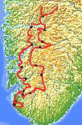
Saturday 9 August Amsterdam- Stavanger - Prekestolen (39
km)
I decide at the very last moment. With the help of my accumulated
Flying Dutchman points, I can get a free ticket to Stavanger. It
is normally quite an expensive flight, but thanks to the
"specials" I am eligible for a free ticket. In the past
few weeks it has been good weather there, and the good weather
looks like holding. This means I can take another look at the
land of fjords, glaciers, elk and magnificent wide horizons. Six
years ago I spent my first cycling holiday in the company of a
group from Cycletours. This year, alone and fully self-supported,
I am returning to the part that impressed me the most - the
mountains and fjords of the Norwegian high country.
With my particular ticket I am allowed 20 kg of luggage. My bike
alone, without any extra baggage, weighs 13 kg, and the KLM bike
box around 4 kg. Over and above that, my remaining luggage comes
to 17 kg, so I choose a lighter box and pack up 4 kg of luggage
to go in the hold. The remaining 13 kg I stuff into 2 Karrimor
panniers which I tie together into a single unit.
Jeroen drives me to the airport. First thing on arrival I collect
my KLM ticket. After waiting 15 minutes it is my turn. Another
passenger pushes in, but then I can claim my ticket. During check
in my bike isn't weighed, and my luggage for the hold has to be
put into a container, which brings the weight up to 8 kg. So
despite my efforts to stay under 20 kg, my total luggage weight
is registered as 23 kg. For the moment there are no further
consequences.
At the check in counter I hear that we are flying in a Fokker 40,
so it is questionable if the bike can travel in the same plane. A
normal KLM bike box would certainly not have fitted in. After I
take my bike to the over size baggage counter, I go and stand in
the customs queue. There is an enormously long queue, and the
customs official motions me over. They are conducting extra
stringent control over the amount of hand luggage that people can
take on board. Hand luggage is limited to one piece weighing 10
kg and within certain measurements, and my hand luggage doesn't
seem to comply. Afraid of being ruled overweight and having to
pay extra, I object strongly. In protest I put on all the clothes
I have with me, and I put my helmet on my head. It's mighty warm
at 30 degrees wearing 2 T-shirts, 2 cycle shirts and two fleece
jerseys, but one has to make a statement. With all this, my
luggage is barely a kilogram lighter. The woman behind the
counter is slightly irritated, but keeps calm. There is nothing
for it but to check in yet another pannier. I therefore surrender
a 3 kg pannier, and I just make it under the 10 kg limit. Lucky
that there is still no penalty for being overweight.
 All dressed up
for winter I pass through customs, after which I quickly stuff
the excess clothes into my already crammed pannier. We are taken
by minibus to a small prop jet. I have a great seat next to the
window. From there I have a good view of Amersfoort, the
IJsselmeer and the Wadden Islands. Around 11 am we land at a
small airfield just outside Stavanger. The bike is delivered
separately from the rest of the baggage, and without any further
difficulties. After loading up my luggage I have yet another
problem. I have to find somewhere to stow the bike box. At
airport security I ask where I can leave the box. The man behind
the counter knows a good place in the bicycle lockup. He writes
the date of my return on a piece of paper and sticks that on the
box. With a tranquil heart I mount my bike. The weather is rather
chilly and it is quite windy. It seems that the weather is about
to change. Along the bike path I take the small climbs over the
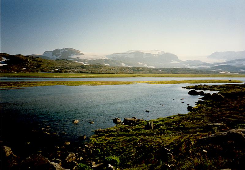
lightly rolling terrain past the Hafrs-fjorden towards Stavanger.
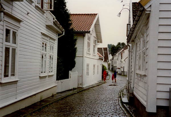
In Madla-Marka, an outlying area of Stavanger, I buy some
groceries for the weekend. The prices are pretty steep. Norway is
known as a country where it is difficult to get Camping gas, so,
as a precaution, I have brought along Minko's spirit stove.
Camping gas is only available here and there. Mostly the blue
bottles are only sold in sporting goods stores in a few large
towns such as Stavanger and Odda. So I buy a bottle of methylated
spirits as well. Outside it is slowly starting to rain. This
changes quickly into a huge downpour. After I have lunch it is a
bit less wet,and I decide to cycle a bit further in towards the
town centre. Having arrived in the centre I take a look at the
Gamle, an old quarter of Stavanger with white wooden houses and
steep, narrow streets. Down by the harbour I procure some
information about the area and boat times from the tourist
bureau. The cloudy weather is no invitation to continue
sightseeing, and I decide to take the boat to Tau. I arrive just
in time, because the barrier closes right behind me. When the
boat moors at Tau three quarters of an hour later it is again
raining buckets. Fully wrapped up I mount my bike. I ride through
the streaming rain to the campground at the foot of the
Prekestolen. When I arrive I set up my tent. The pleasant but
expensive camping ground is run by a Dutch family. It costs a
minimum of 80 krone (=24 guilders) for one person with a tiny
tent.
All dressed up
for winter I pass through customs, after which I quickly stuff
the excess clothes into my already crammed pannier. We are taken
by minibus to a small prop jet. I have a great seat next to the
window. From there I have a good view of Amersfoort, the
IJsselmeer and the Wadden Islands. Around 11 am we land at a
small airfield just outside Stavanger. The bike is delivered
separately from the rest of the baggage, and without any further
difficulties. After loading up my luggage I have yet another
problem. I have to find somewhere to stow the bike box. At
airport security I ask where I can leave the box. The man behind
the counter knows a good place in the bicycle lockup. He writes
the date of my return on a piece of paper and sticks that on the
box. With a tranquil heart I mount my bike. The weather is rather
chilly and it is quite windy. It seems that the weather is about
to change. Along the bike path I take the small climbs over the
lightly rolling terrain past the Hafrs-fjorden towards Stavanger.
In Madla-Marka, an outlying area of Stavanger, I buy some
groceries for the weekend. The prices are pretty steep. Norway is
known as a country where it is difficult to get Camping gas, so,
as a precaution, I have brought along Minko's spirit stove.
Camping gas is only available here and there. Mostly the blue
bottles are only sold in sporting goods stores in a few large
towns such as Stavanger and Odda. So I buy a bottle of methylated
spirits as well. Outside it is slowly starting to rain. This
changes quickly into a huge downpour. After I have lunch it is a
bit less wet,and I decide to cycle a bit further in towards the
town centre. Having arrived in the centre I take a look at the
Gamle, an old quarter of Stavanger with white wooden houses and
steep, narrow streets. Down by the harbour I procure some
information about the area and boat times from the tourist
bureau. The cloudy weather is no invitation to continue
sightseeing, and I decide to take the boat to Tau. I arrive just
in time, because the barrier closes right behind me. When the
boat moors at Tau three quarters of an hour later it is again
raining buckets. Fully wrapped up I mount my bike. I ride through
the streaming rain to the campground at the foot of the
Prekestolen. When I arrive I set up my tent. The pleasant but
expensive camping ground is run by a Dutch family. It costs a
minimum of 80 krone (=24 guilders) for one person with a tiny
tent.
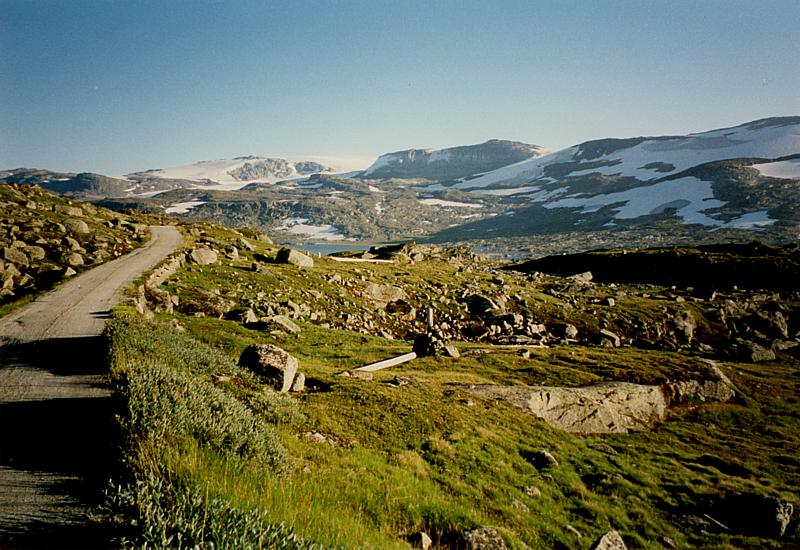
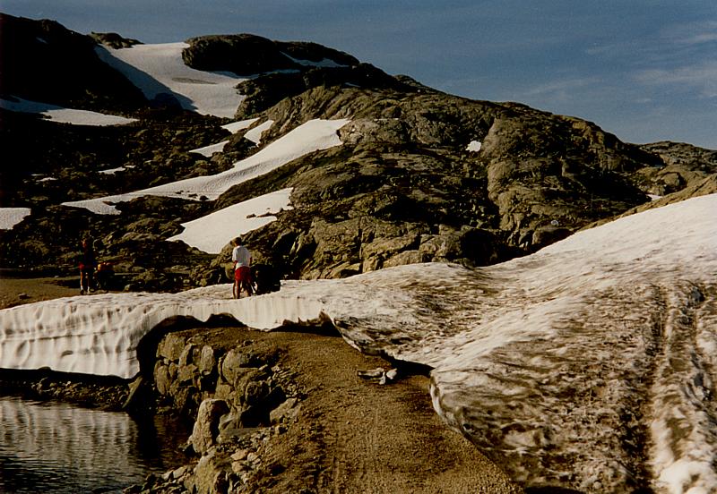
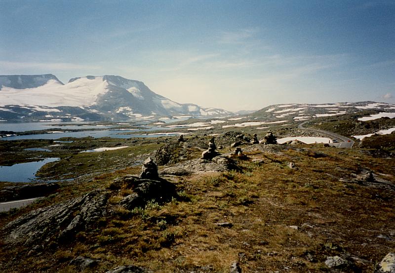
Sunday 10 August Prekestolen - Lysefjord - Lysebotn (29 km)
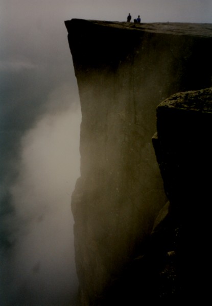 The
following morning I get up early. I can leave my tent there until
four pm. I plan to cycle to the Prekestolen this morning. This is
a world famous rock overhang that beetles around 600 meters above
a fjord. A thick blanket of cloud hangs over the Norse
countryside. Despite the prevailing weather, about 8 am I start
the climb towards the foot of the walking path up to the
Prekestolen. The four kilometer climb goes well, but because of
an incorrectly mounted front derailleur I cannot use my 28 tooth
front chainwheel, and I sweat quite freely on the way up. At the
end of the path there is an alpine hut with a large parking area.
So early in the morning it is still very quiet. I lock my bike to
a tree and climb upwards. It is still as foggy as ever. The path
climbs up steeply, and leads through a wood and a muddy area
where I overtake a few people. After that there is a steep
passage where you have to use hands as well as feet to reach the
top. According to the booklets it takes two hours to traverse the
path, but after only one and a quarter hours I am at the end of
it. The path ends suddenly, but there is nothing at all to be
seen through the thick fog.
The
following morning I get up early. I can leave my tent there until
four pm. I plan to cycle to the Prekestolen this morning. This is
a world famous rock overhang that beetles around 600 meters above
a fjord. A thick blanket of cloud hangs over the Norse
countryside. Despite the prevailing weather, about 8 am I start
the climb towards the foot of the walking path up to the
Prekestolen. The four kilometer climb goes well, but because of
an incorrectly mounted front derailleur I cannot use my 28 tooth
front chainwheel, and I sweat quite freely on the way up. At the
end of the path there is an alpine hut with a large parking area.
So early in the morning it is still very quiet. I lock my bike to
a tree and climb upwards. It is still as foggy as ever. The path
climbs up steeply, and leads through a wood and a muddy area
where I overtake a few people. After that there is a steep
passage where you have to use hands as well as feet to reach the
top. According to the booklets it takes two hours to traverse the
path, but after only one and a quarter hours I am at the end of
it. The path ends suddenly, but there is nothing at all to be
seen through the thick fog.
There are two Germans there as well, looking a bit taken aback. I
decide to wait with them until there is maybe something to see,
and I set my deadline at 11 am. After a while more and more
people arrive, especially Germans, slightly disappointed because
the promised view just isn't there.
Around 10 am the fog suddenly lifts and we are afforded a ten
second peek. Then the thick cloud blanket falls again. After
waiting another half hour suddenly a magnificent, spectacular
fjord landscape unfolds. After taking a few photos I begin the
descent. Just in time because the heavy mist returns and a huge
stream of people is inching upwards. This varies from oldies,
hikers with the wrong shoes, to people with prams and dogs. Many
are sitting dispirited before a difficult section of the path and
seem somehow to have underestimated the "walk".
An hour later I am standing back down in the parking area, and
within 15 minutes I am back at the camp ground. While I am
striking my tent I meet a German cyclist who started in
Kristiansand and has cycled to Stavanger via the fjord coastline.
He plans to climb the Prekestolen this afternoon, and I wish him
success with it.
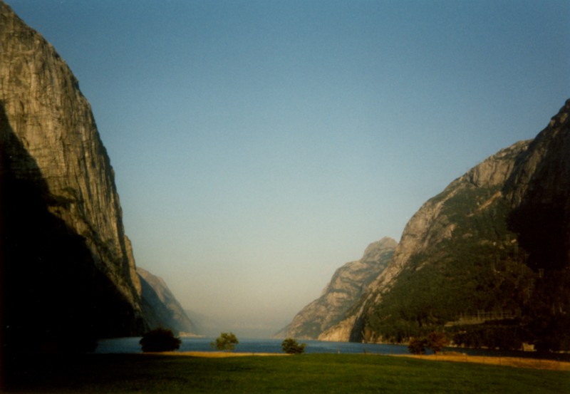 The weather has changed
completely. After about an hour's cycling I am standing at the
Lysefjord Information Centre in Oanes. The boat through the
Lysefjord leaves from here, travelling below the Prekestolen to
Lysebotn. This doesn't leave for two hours yet, so I can enjoy
the good weather for a little longer. The boat arrives around 4
pm. The view across the fjord is mindbendingly beautiful and so
spectacular. The steep fjord coastline rises at least 1300 meters
above the water. In contrast to this morning, the Prekestolen is
completely cloud free, and will probably attract crowds of
visitors. The boat pulls in to numerous small jetties and
harbours. Some hamlets are even only reachable by boat, and
consist almost completely of holiday cottages. Around the edges
of the Lysefjord there are also a number of seals to be seen.
High above the water's edge we can still just make out the
Kjerag. This is a large round stone wedged between two walls of
rock that rise up 1132 meters above the fjord. After two and a
half hours' travel we arrive at the small place called Lysebotn,
consisting of a church, a campground, a small shop, and a handful
of cottages. It is already six thirty, and consequently too late
to cycle any further, because I am almost through my culinary
supplies. At the very pricey campground (100 krone) I search out
a pretty spot with a fantastic view over the Lysefjord. There is
a Dutch girl working at this campground too.
The weather has changed
completely. After about an hour's cycling I am standing at the
Lysefjord Information Centre in Oanes. The boat through the
Lysefjord leaves from here, travelling below the Prekestolen to
Lysebotn. This doesn't leave for two hours yet, so I can enjoy
the good weather for a little longer. The boat arrives around 4
pm. The view across the fjord is mindbendingly beautiful and so
spectacular. The steep fjord coastline rises at least 1300 meters
above the water. In contrast to this morning, the Prekestolen is
completely cloud free, and will probably attract crowds of
visitors. The boat pulls in to numerous small jetties and
harbours. Some hamlets are even only reachable by boat, and
consist almost completely of holiday cottages. Around the edges
of the Lysefjord there are also a number of seals to be seen.
High above the water's edge we can still just make out the
Kjerag. This is a large round stone wedged between two walls of
rock that rise up 1132 meters above the fjord. After two and a
half hours' travel we arrive at the small place called Lysebotn,
consisting of a church, a campground, a small shop, and a handful
of cottages. It is already six thirty, and consequently too late
to cycle any further, because I am almost through my culinary
supplies. At the very pricey campground (100 krone) I search out
a pretty spot with a fantastic view over the Lysefjord. There is
a Dutch girl working at this campground too.
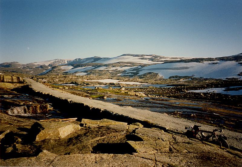
Monday 11 August Lysebotn - Hoslemo (132 km)
One of Norway's most difficult climbs starts at Lysebotn.
According to the King of the Mountains site on the internet:
Lysefjordveien (Lysebotn-Edneram) 950
meters/3,117 feet)
Ride information: Has been called one of Norway's "wildest
climbs" because of its 27 hairpin turns - a 950 meter
vertical climb, with the first 6 kilometers rising 880 meters
with an average grade of about 12-13%
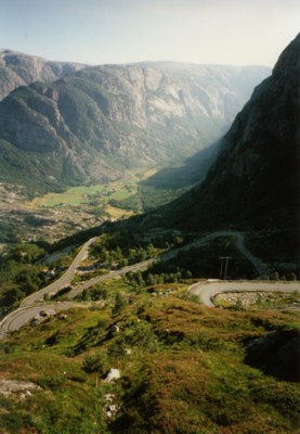 The climb is
therefore an absolute must for me. I plan to leave early, as I
want to camp somewhere in the Sirdal, about one hundred
kilometers further up. The village shop and the campground shop
don't open until 11am. I take the gamble and start the climb
around 9am. I cycle upwards at a steady pace. After a few hundred
meters I plunge into a very dark tunnel. This climbs for about
one and a half kilometers, and includes a hairpin bend, but
luckily the asphalt surface is good. The halogen lamp and the
absence of cars makes the passage "a piece of cake". At
a quarter to ten I arrive at the mountain restaurant Oygardstol,
and I have the worst part of the climb behind me. Although the
restaurant does not open until 10am, I am able to wangle some of
Saturday's leftover rolls from the kitchen, for free.
The climb is
therefore an absolute must for me. I plan to leave early, as I
want to camp somewhere in the Sirdal, about one hundred
kilometers further up. The village shop and the campground shop
don't open until 11am. I take the gamble and start the climb
around 9am. I cycle upwards at a steady pace. After a few hundred
meters I plunge into a very dark tunnel. This climbs for about
one and a half kilometers, and includes a hairpin bend, but
luckily the asphalt surface is good. The halogen lamp and the
absence of cars makes the passage "a piece of cake". At
a quarter to ten I arrive at the mountain restaurant Oygardstol,
and I have the worst part of the climb behind me. Although the
restaurant does not open until 10am, I am able to wangle some of
Saturday's leftover rolls from the kitchen, for free.
I enjoy the lovely view of the many hairpin bends, and the fjord,
and the village in the valley, towards which I am now riding.
After this the climb is no longer so difficult, but the scenery
remains superb. Many fabulous kilometers follow, through a virgin
mountain landscape. After ten or so kilometers the road descends
and the surrounding countryside turns to tundra. The broad
valleys are covered with lots of small trees, and are dotted with
small mountain lakes.
The Sirdal quickly follows. At Suleskard I turn left and make a
short stop. I give directions to a couple of motorists (one a
Dutchman). After this the climb out of the Sirdal begins, over
the RV 45. The climb is pretty difficult , what with the hot
weather and bright sunshine. Several hundred meters in front of
me I see two cyclists struggling uphill on foot. They are
obviously having a lot of trouble, and are pushing their heavily
laden bikes in front of them. When I cycle past at some
roadworks, the female cyclist calls to her companion "Hey,
he's got mountain gears". They are more Dutch tourists, who
have typically underestimated the mountains. I reply: "Yep,
you really need them around here", and they look at me,
slightly stunned. I don't feel like interrupting this difficult
climb to stop and have a chat, so I just keep riding.
The steep part of the ascent goes on for another 5 kilometers.
After that I find myself once more in a splendid rugged alpine
landscape with many mountain lakes. This lasts for about 30
kilometers. Snow lies about in a few places, and the road is very
quiet. During the steep descent into the Setesdal, where I reach
a maximum speed of 71 kph, I meet a quartet of cyclists working
their way up with great difficulty. The red Ortlieb panniers lead
me to suspect that they are German, but I'm not in the mood to
investigate further. It is just as hard to stop and chat in the
middle of a fast descent as a difficult climb.
In the Setesdal I finally find a café where I can refill my
bidons. To appease the worst pangs of hunger and thirst I buy a
cola and a sweet pastry. It is 4 pm when I reach the village of
Valle, much too early to stop. I decide to cycle on through the
splendid Setesdal. The slopes beside the river are covered with
deep green forests, which is quite a change from the landscapes I
have been cycling through today.
In Flateland I finally do a comprehensive shop. On the map I see
that there are quite a few campgrounds in the area around Byklom,
and I decide to ride to one of them. The road rises gently and
the landscape is once again tundra-ish. There is no campground in
Byklom, but on the information board I see that there is one in
Hoslemo, which means riding on another 15 kilometers. On the way
I pass a number of splendid wild camping places, but I keep
riding. The campground in Hoslemo is not very attractive, and is
completely empty. There is no other campground in the immediate
vicinity, and it is already 7.30, so I ring the bell. A middle
aged Norwegian woman opens the door. She speaks no English, but
it seems that it is possible to camp there. The facilities are
very limited and shabby. I have to fetch the key from the woman.
The shower costs 5 krone, but is over within 30 seconds. The site
is definitely not worth the 50 krone I pay for it. As I am
cooking dinner lots of mosquitoes arrive to keep me company in my
solitude. I climb into my sleeping bag straight afterwards, and
bemoan the fact that I didn't attempt to wild camp.
Tuesday 12 August Hoslemo - Roldal (106 km)
I break camp quickly and mount my bike after a reasonable
night disturbed slightly by the noise of heavy vehicles driving
past. After 20 flat kilometers I arrive in Hovden at 11am. It is
a holiday destination and has the regular facilities. It seems my
holiday will be a bit more expensive than I expected, due to the
high cost of campsites and food. The local auto teller does not
accept my giro pass. After doing a bit of shopping I have a good
breakfast in the little square in the middle of town. Some
Norwegians also have the same idea and are enjoying the morning
sun.
The kilometers after Hovden climb gently. I had expected a stiff
ascent, but I discover I am already quite high up. The road
meanders over the plateau without too much climbing. After the
highest point at 917 meters the descent into Haukeligrend cuts in
quickly. The descent is a bit steeper than the ascent, and I
quickly get to 60 kph. When I find myself on the steepest part I
set myself up for a fast downhill run. Suddenly I hear a strange
click, so I don't follow through. After the descent I inspect my
front wheel. One of my spokes has collapsed under the force of
the descent. Lucky that I hadn't gone any faster, for a sudden
somersault at 60 kph is not a pleasant thought.
At the petrol station I inquire about the closest bike shop. It
seems that there isn't one in the immediate vicinity. So I
temporarily repair my broken spoke with an emergency spoke. The E
134 where I now find myself climbs gradually towards the
Haukelifjell plateau. In the beginning the road is still nice and
quiet, but becomes busier as I go on. The scenery is
overpoweringly beautiful as before, but the sky is somewhat
cloudy. The large lakes and snow covered mountains again make a
deep impression. The very busy main road dives into a few
tunnels, but on the bike you can follow a path that goes around
the tunnels. This path is narrow, but sealed, and very scenic.
The path climbs hardly any more than the tunnels, and the view is
heaps better.
I only have to go through one tunnel. At that particular time the
tunnel is extremely quiet, and very well lit. By Stavnat lake I
take a short rest. An old Norwegian couple in an ancient Ford
Taunus start chatting with me. They think it is fantastic that I
am cycling through their country. She speaks very limited
English, and he speaks none at all, but with the help of a few
words and some sign language I can make myself understood quite
well. They advise me to cycle along the Hardanger fjord in the
area of Kwam and Nordheimsund. I am also given a tourist guide to
the area.
At the next tunnel the path leads to the highest point at 1148
meters. Immediately before the top the path passes by a large
wall of snow. The final tunnel is encountered on the descent into
Roldal. The road around the tunnel is blocked by a barrier and a
few stone blocks. I decide to take this road nevertheless, and
can easily ride around the blockade. The road has a number of
hairpin bends, and plunges steeply down towards the small village
of Roldal. In the village I hunt for a campsite at 6.30. The
place has no bike shop, so I have to ride on the emergency spoke
for at least another day.
The campground is excellent and only costs 40 krone. At the
campground I have a chat with a family that had waved to me 130
kilometers back in Hovden. They had asked themselves if I might
not have a motor in my large panniers….
In the evening I visit also the pole church and go for a short
walk.
Wednesday 13 August Roldal - Ovre Eidfjord (126 km)
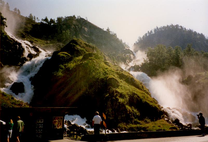 After pulling my tent down I do some shopping at
the local service station. The climb begins immediately. The
quiet secondary road splits off from the main road that
disappears into the mountains via a tunnel. The climb zigzags
upwards with many hairpin bends, and there is little traffic. At
the top (1067 m) I meet two German cyclists who are heading in
the opposite direction. They have already done quite a trip,
including the Rallerveien. This famous unsealed cycle path
between Haugostol and Flam is good to cycle in their opinion.
From here they are going further along the path that I have come
down, in the direction of Geilo. I plunge into the descent
towards Odda. On the way down I come across many bikers
travelling in the opposite direction. At the Latefossen I make a
short stop. Here the water foams onto the road surface from the
branching waterfall. A bit later two more Dutch cyclists arrive
at the waterfall. They began in Kristiansand, having arrived
there by cyclebus and boat. They were also in Stavanger on the
weekend. One of the guys had broken a spoke, but the bike shop
didn't have the tools to undo his Suntour freewheel, so they had
to wait until the Monday, then they took the hovercraft to Sauda,
which only took two hours. Today they are also travelling to
Odda, where they will stay to do a glacier walk.
After pulling my tent down I do some shopping at
the local service station. The climb begins immediately. The
quiet secondary road splits off from the main road that
disappears into the mountains via a tunnel. The climb zigzags
upwards with many hairpin bends, and there is little traffic. At
the top (1067 m) I meet two German cyclists who are heading in
the opposite direction. They have already done quite a trip,
including the Rallerveien. This famous unsealed cycle path
between Haugostol and Flam is good to cycle in their opinion.
From here they are going further along the path that I have come
down, in the direction of Geilo. I plunge into the descent
towards Odda. On the way down I come across many bikers
travelling in the opposite direction. At the Latefossen I make a
short stop. Here the water foams onto the road surface from the
branching waterfall. A bit later two more Dutch cyclists arrive
at the waterfall. They began in Kristiansand, having arrived
there by cyclebus and boat. They were also in Stavanger on the
weekend. One of the guys had broken a spoke, but the bike shop
didn't have the tools to undo his Suntour freewheel, so they had
to wait until the Monday, then they took the hovercraft to Sauda,
which only took two hours. Today they are also travelling to
Odda, where they will stay to do a glacier walk.
Odda is a large tourist town with a lot of shops. I have my spoke
repaired at the local sports complex cycle shop. My emergency
spoke has stood up to two difficult ascents, but I prefer to
change it before the really difficult dirt surface work begins.
The bike shop is situated on the first floor, so I have to unload
my stuff before dragging the bike up the stairs by the handlebar
stem. From a few newspaper articles on the wall, I see that the
mechanic is an up and coming local cycling talent. He looks after
my Cannondale admirably. At 100 Krone the bill is rather
expensive, but compared to one night's camping it's not so bad,
and you get a lot more pleasure out of it.
After taking on board some money and some food I ride further
along the Sorfjorden. I can't avoid the tunnel just before
Tyssedal, but it is well lit. For a long time the road follows
the coastline of the fjord, so it is quite flat. For the whole
distance you can see the gigantic icecap of Folefonni. Many
glacial tongues and waterfalls plummet down below. The road
between Eidfjord and Ovre Eidfjord is under repair and even
closed at times during the day. I therefore cycle over the flat
road through the Eidfjordvatnet as far as Ovre Eidfjord. Once
arrived I debate whether to go wild camping, but the campground
is such a steal (20 krone), that you wouldn't let a warm shower
go begging. The campground is simple, but well equipped. There is
also a large bus group of French children, which makes things
pretty lively. Even the mosquitoes don't know when to stop, so
the Jungle oil is called into service once again.
Thursday 14 August Ovre Eidfjord - Hallingskeid (104 km)
Do some shopping this morning at the local
supermarket. After that I start the steep climb out of the fjord
through the Mabodalen. The cycle route follows the old road,
while the motor way again disappears into a number of tunnels.
Only hikers, cyclists, and tourists on a little train can enjoy
the view of the narrow gorge. At the 181 meter high Voringfossen
a waterfall drops into the depths from Hotel Fossli with an
enormous din. After the waterfall the climb is no longer
particularly steep. Now and then I catch a glimpse of the
Hardanger Jokulen. To the south the enormous plateau of the
Hardangervidda obtrudes, the hikers' domain. No roads cross
through this nature area. The Norwegians are busy trying to make
the road ready for winter. Large pieces of asphalt have frozen
and come off, so the road around here is not very comfortable to
travel. A section of the bitumen is still soft, so a thick layer
of tar remains stuck to my tyres. At the highest point, 1250
meters, I pause and enjoy the beautiful scenery all around me.
After I have filled my bidons at the alpine hut I judder onwards
over the bumpy surface.
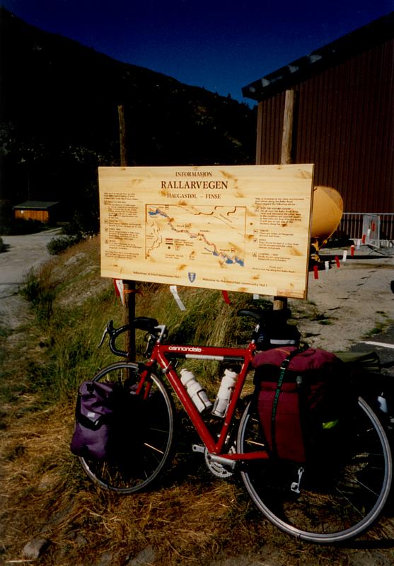
 I arrive in
Haugostol around 3.30 pm, the start of the Rallerveien, a cycle
route along an old railway line. A large parking area is full of
Norwegians loading and unloading bicycles. This is obviously THE
bikepath of Norway. This path is mentioned in several places on
the internet as one of the best parts of Norway. The start of the
unsealed path is quite flat and good for cycling. There are many
Norwegians who are already returning from a day's cycling. After
Hallingskarvet the landscape becomes more rugged, and barren
mountain tops covered in eternal snow jut out above the mountain
lakes. The road surface requires me to pay closer and closer
attention, but remains rideable. I then arrive in Finse, one of
the few places along the path. Finse consists of several alpine
huts and a train station. It is already 7pm, and I call the
Netherlands to wish my brother Jeroen a happy birthday. At the
station I fill my bidons with water, and my jerry can, just to be
safe. There are no official camping places along the route, but I
have been told there are many places where you can pitch your
tent. This is certainly the case just outside Finse, but it is
still a bit too early to stop. The path gets continually worse,
and crosses and recrosses the railway line. Along the line there
is still a lot of building activity and also a large number of
barracks style buildings. After that the bike path runs through
the railway tunnel, where great sheets of snow are lying around.
After one small tunnel the path is so bad that I have to dismount
and carry my bike for a few hundred meters. It gets dark quickly,
but I can't find a flat piece of ground for my tent. Suddenly I
see tents pitched everywhere, and I finally find a suitable spot
next to the path at a quarter past nine. I set up my tent twenty
or thirty meters from a cycling duo, a father and son. I cook my
meal in the dark, and I take a minimal wash in the stream.
I arrive in
Haugostol around 3.30 pm, the start of the Rallerveien, a cycle
route along an old railway line. A large parking area is full of
Norwegians loading and unloading bicycles. This is obviously THE
bikepath of Norway. This path is mentioned in several places on
the internet as one of the best parts of Norway. The start of the
unsealed path is quite flat and good for cycling. There are many
Norwegians who are already returning from a day's cycling. After
Hallingskarvet the landscape becomes more rugged, and barren
mountain tops covered in eternal snow jut out above the mountain
lakes. The road surface requires me to pay closer and closer
attention, but remains rideable. I then arrive in Finse, one of
the few places along the path. Finse consists of several alpine
huts and a train station. It is already 7pm, and I call the
Netherlands to wish my brother Jeroen a happy birthday. At the
station I fill my bidons with water, and my jerry can, just to be
safe. There are no official camping places along the route, but I
have been told there are many places where you can pitch your
tent. This is certainly the case just outside Finse, but it is
still a bit too early to stop. The path gets continually worse,
and crosses and recrosses the railway line. Along the line there
is still a lot of building activity and also a large number of
barracks style buildings. After that the bike path runs through
the railway tunnel, where great sheets of snow are lying around.
After one small tunnel the path is so bad that I have to dismount
and carry my bike for a few hundred meters. It gets dark quickly,
but I can't find a flat piece of ground for my tent. Suddenly I
see tents pitched everywhere, and I finally find a suitable spot
next to the path at a quarter past nine. I set up my tent twenty
or thirty meters from a cycling duo, a father and son. I cook my
meal in the dark, and I take a minimal wash in the stream.
Friday 15 August Hallingskeid - Hornadalen (75 km)
 After a good
night's rest and some breakfast I break camp and proceed along
the Rallerveien. My neighbours are also up and at it, and start
off at the same time as me. With the ATB's they are a bit faster
than me along the rough terrain, but in the steeper parts I catch
up to them again. The scenery is extremely beautiful. There is
water running everywhere, the view of the glaciers is fantastic,
and there is even snow still covering the path. Now and then an
ATBer comes along the path in one direction or the other. I also
overtake two Americans who came past my camp early in the
morning. Just past Hallingskeid the countryside changes. A large
waterfall squeezes itself through a narrow crevice. The broad
plateau becomes a narrow ravine. The path dips down steeply
through the ravine, and after that through a wood, to end at two
small mountain lakes. More and more hikers, and fishermen also,
appear on the path. I make a short rest stop by the last lake,
the Vatnahalsen. Finally, at Myrdal I am standing on the edge of
a deep abyss. The road through the Myrdal clings tight to the
wall, and descends with an average gradient of 17% and many
hairpin bends. A sign warns against travelling too fast down
hill: "Very dangerous descent, watch your speed, you never
know what surprises are waiting around the bend".
After a good
night's rest and some breakfast I break camp and proceed along
the Rallerveien. My neighbours are also up and at it, and start
off at the same time as me. With the ATB's they are a bit faster
than me along the rough terrain, but in the steeper parts I catch
up to them again. The scenery is extremely beautiful. There is
water running everywhere, the view of the glaciers is fantastic,
and there is even snow still covering the path. Now and then an
ATBer comes along the path in one direction or the other. I also
overtake two Americans who came past my camp early in the
morning. Just past Hallingskeid the countryside changes. A large
waterfall squeezes itself through a narrow crevice. The broad
plateau becomes a narrow ravine. The path dips down steeply
through the ravine, and after that through a wood, to end at two
small mountain lakes. More and more hikers, and fishermen also,
appear on the path. I make a short rest stop by the last lake,
the Vatnahalsen. Finally, at Myrdal I am standing on the edge of
a deep abyss. The road through the Myrdal clings tight to the
wall, and descends with an average gradient of 17% and many
hairpin bends. A sign warns against travelling too fast down
hill: "Very dangerous descent, watch your speed, you never
know what surprises are waiting around the bend".
With brakes squeezed tight, I make my way down at 5 kph. The road
surface is strewn with large stones, and on this steep section I
have difficulty keeping the bike under control, and use my foot
to keep my balance. I can truly imagine that this climb is
impossible to do in the opposite direction. After about three
kilometers the road is again rideable, and the bike can make some
speed. There are more and more hikers on the path, and after a
few gates the asphalt begins.
Flam is at the end of the train line and is situated on the
Aurlandsfjord. It is a tourist town, full of activity. When I get
there I buy some cards for this one and that one, and refill my
bidons. From here most people take the fast boat to Gudvangen
through Naeroyfjorden, or to Kaupanger. I decide to cycle on to
Aurland. I camped here in 1991, but now it is only used as a
supply stop for those passing through. In the little square I do
some shopping and eat some rolls. Enjoying the streaming
sunshine, I listen to a local band who are making an appearance
in the square.
Around four o'clock I remount my bike and begin the climb up the
road I came down in 1991. I plan to wild camp again, higher up on
the plateau. In Norway you are allowed to set up your tent
anywhere you like, but in fact there is only room to do it in the
mountains. In the valleys everywhere is occupied with farms,
grassland and buildings. The climb is not enjoyable at the end of
the day, and is mighty difficult. I have the idea that this side
of the climb is steeper and more difficult than the other side.
The path creeps upwards along the edge of the woods, and affords
many scenic views of the distant Aurlandsfjord. The fjord
disappears from sight, and a broad panorama unfolds, showing the
valley and the remainder of the climb. The next 10 kilometers of
climbing are in full view, and I follow the cars that are
creeping upwards through the hairpin bends. After an hour's
climbing I am past this section, and am cycling across the
plateau. The path is still rising, but is interspersed with short
downhills. There is much less snow lying around than 6 years ago
and I look for a place where I can set up my tent undisturbed.
The terrain around here is too uneven, and I reach the highest
point (1306 meters). Quickly after that, about 8 pm, I find a
good wildcamping site out of view of passing traffic. To get
there I have to push my fully laden bike twenty or thirty meters
up the mountain, but it is a fabulous spot.
Saturday 16 August Hornadalen - Nes (106 km)
This morning is pretty chilly. I ride down to
Laerdal and ride past a few points that I recognise from 6 years
back. The surrounding area has changed little, and looks as
splendid as ever. On the way down I say hello to two cyclists who
are just beginning the ride up. When I arrive at the fjord I see
that the ferry between Revnes and Kaupanger no longer runs as a
new tunnel has been built, with a crossing over the Sognefjord.
Luckily there is a punt that leaves Lauerdal for Kaupanger four
times per day, and I am in plenty of time for the 12 o'clock run.
From the boat we can enjoy the sight of several dolphins who are
playing around in the deep fjord. When the boat passes close by
them they go very quiet, so that it is difficult to photograph
them. I am the only one to leave the boat in Kaupanger, all my
fellow passengers are going to Gudvangen.
The road climbs out of the valley to Sogndal, and then climbs
again to Hafslo. The main road takes the tunnel, but I again
choose the narrow road parallel with the tunnel. It is more like
a footpath where I can just get through on the bike. The path
keeps climbing up through a wood, to finally reach a small lake
(Veitastrondvatnet) at around the 200 meter level. After Haslo
the road keeps climbing through a wood, and after this it falls
again into the Sognefjord. When I arive in Gaupne I check out the
camping ground, but 80 Krone is too much to pay, and I decide to
cycle on. Today's plan to cycle to the Nigardsbreen glacier is
ditched, and I find a pleasant camping ground in Nes.
After pitching my tent I decide to take a short ride to Luster,
where I also camped 6 years ago. In Luster, also, little has
changed in the past 6 years. After a bit of a search I find the
track to the dead-end Dalsdalen road. This is a pleasant little
valley with many old farms. At the end of the road I turn around
again and arrive back at the Nes campsite around 7 pm.
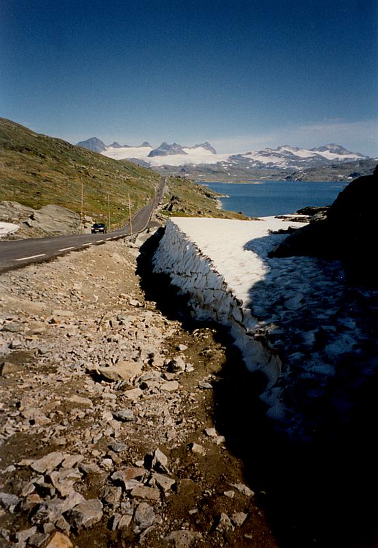
Sunday 17 August Nes - Sognefjellsvegen - Nes
Today is a rest day and I go for a ride without all my gear.
The route runs via Luster past the waterfall at Vassbakken just
before Fortun. Then the steepest part of the climb begins. At the
Turtago sporthotel the toll road splits off to Ovre Ardal, the
way I travelled in 1991. Today, however, I ride past, towards the
highest road pass in Norway. Just after the turnoff there is a
knockout view of the 2000 meter high monsters of the Jotunheimen
massif. Next there follows a steep section with diverse hairpin
bends that reaches up to 1200 meters and deposits you on the
plateau above. A magnificant landscape opens to view, where a
number of mountain climbers have set up their camp. Wherever you
look there are glaciers, rugged mountain tops and mountain lakes.
This is the new highlight after the magnificent Rallerveien.
After the Sognefjellshytta you come to the highest point, the
Fantestein, 1434 meters, reached via the Norse Pass. I pause here
to enjoy the beautiful views into the distance. Today is the
weekend, so it is very crowded. Many others have also come to the
highest point today. Shortly after I turn around and I ride as
slowly as possible through the impressive landscape. Just before
the descent begins I turn off at Hervadammen and follow a little
dead-end unsealed road to the Skalavatnet storage dam. The
unsealed road is pretty rough, but cyclable. The descent to the
Sognefjord goes smoothly, and I arrive back at camp at around 7
in the evening.
Monday 18 August Nes - Nigardsbreen - Vangnes (155 km)
 I leave early in the morning, fully laden. In
Gaupne I do a bit of shopping and buy extra film at the same
time. The good weather and the magnificent scenery force me to
take a lot of photographs. At the supermarket I see two more
cyclists. The weird thing is that while you are on the track you
see a large number of (mostly German) cyclists, but at the
campgrounds you can count them on one finger, and this finger I
am always pointing at myself, as I've only once met another
cyclist at a campground. They are probably all shocked at the
highly inflated prices, and so camp wild and raise one finger
(probably the middle finger) at the campground operators. Well,
why should you have to pay 30 guilders for a piece of grass, when
you can set up in the wild for nothing.
I leave early in the morning, fully laden. In
Gaupne I do a bit of shopping and buy extra film at the same
time. The good weather and the magnificent scenery force me to
take a lot of photographs. At the supermarket I see two more
cyclists. The weird thing is that while you are on the track you
see a large number of (mostly German) cyclists, but at the
campgrounds you can count them on one finger, and this finger I
am always pointing at myself, as I've only once met another
cyclist at a campground. They are probably all shocked at the
highly inflated prices, and so camp wild and raise one finger
(probably the middle finger) at the campground operators. Well,
why should you have to pay 30 guilders for a piece of grass, when
you can set up in the wild for nothing.
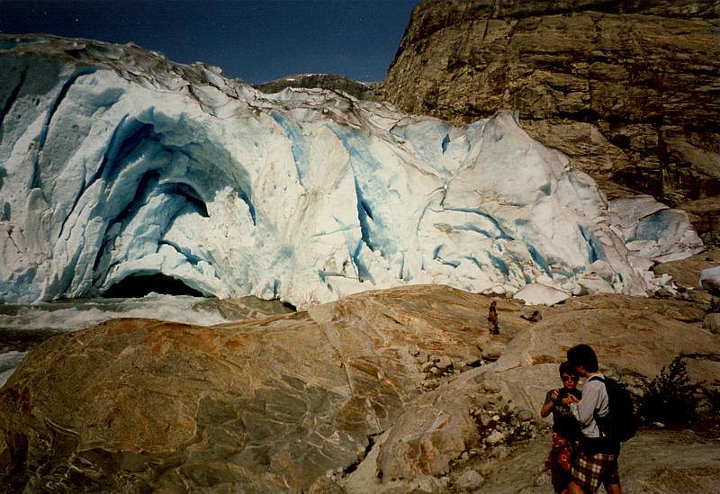
I am returning to Gaupne to take a look at the Nigardsbreen
glacier. This one forms the lower part of the second largest
glacier in Europe, the Jostedalsbreen. The Nigardsbreen glacier
is situated at the end of a valley, the terminal point of a dead
end road. I get ready for a difficult climb of around 25 km, but
I enjoy it immensely. Inside an hour I reach the information
centre where you already get a nice view of the glacial tongue.
You then have another three or so kilometers to ride over a toll
road, but it is free for cyclists. At the parking area you can
take a boat to the glacier, or you can walk up a path. This path
is very rugged and I would have to wade through many small
strams. Alas, I don't have my hiking boots with me, so I choose
to take the boat. It is very windy during the boat trip. A large
group with climbing irons and glacier gear also gets in the boat.
It is possible to make an excursion onto the glacier, at a price.
Again, alas, I don't have the proper gear with me, but I probably
don't have enough time for it anyhow. Arrived at the glacier I
take several photos of the impressive cracks in the blue ice.
When I see the group all fastened together by a rope, creeping
forwards foot by foot, I am no longer disappointed that I don't
have the right gear with me. The return trip through the valley
to the Sognefjord is uneventful. Past Sognedal the road becomes a
bit narrower. Cars drive past you very carefully, and some even
wait before overtaking you. In comparison with other countries,
the traffic is very well behaved and courteous in regard to
cyclists. Just before Sognedal there is evidence of an accident
that did not turn out well. On the surface of the road the chalk
marks are still obvious and some children are laying flowers on
the spot where a fatality has probably occurred. Just one more
reason to be careful when cycling on narrow roads.
From Sognedal I ride 37 kilometers along the fjord. With the sun
low and with really tired legs I complete the stage. Around 8pm I
arrive in Hella where I catch the ferry to Vangnes. The first two
campgrounds don't look very pleasant. The first is completely
empty, the second is completely full, of Germans. I pitch my tent
in the third one around 9 o'clock. It is a pleasant campground on
the edge of the fjord, and not too expensive either. A terribly
strong wind starts up, perhaps a sign that there's a change of
weather in the air.
I have a bit of a chat with a Dutch couple who are touring around
by car. They have already been to Trondheim, and will finish
their three week trip at Hadangervidda. Trondheim, Geiranger, and
the Trollstigen are too far away for me, so I will keep them for
next time.
Tuesday 19 August Vangsnes - Granvin (115 km)
 The day begins with a quiet ride along the fjord to Vik. Here I
do some shopping and take a look at the pole church. The sky is
very overcast, but it remains dry. The climb up out of the fjord
is a bit more difficult than expected. During a large part of the
climb I can see back over the valley and the Vik pole church. I
pause momentarily at a tunnel which is just before the start of
the Stolsheimen plateau. The tunnel is unlit, but the light of
the Specialized head lamp takes me safely through this dark
cavern. The highest point (986 m) is quickly reached and I am
again cycling through an inhospitable mountain region full of
lovely lakes. A tandem and a pair of cyclists ride towards me.
They have been riding across the plateau a bit longer than me, as
they are dressed warmly. After that I pull on my red fleece
jersey, because it is beginning to cool down quite a bit.
The day begins with a quiet ride along the fjord to Vik. Here I
do some shopping and take a look at the pole church. The sky is
very overcast, but it remains dry. The climb up out of the fjord
is a bit more difficult than expected. During a large part of the
climb I can see back over the valley and the Vik pole church. I
pause momentarily at a tunnel which is just before the start of
the Stolsheimen plateau. The tunnel is unlit, but the light of
the Specialized head lamp takes me safely through this dark
cavern. The highest point (986 m) is quickly reached and I am
again cycling through an inhospitable mountain region full of
lovely lakes. A tandem and a pair of cyclists ride towards me.
They have been riding across the plateau a bit longer than me, as
they are dressed warmly. After that I pull on my red fleece
jersey, because it is beginning to cool down quite a bit.
After ten or so kilometers the road drops quickly by way of a
number of hairpin bends down past Helgatun. The narrow gorge is
very impressive. At Vinje I turn left into the busy E68, and just
before Voss I take another cycle path. Voss lies at the edge of
the Hardangervidda. In touristy Voss I get a few supplies and
some more money. I start to cycle off in the wrong direction, but
correct myself just in time. The cycle path runs along the old
railway line, and I keep a look out for suitable wild camping
spots. At Skerjevossen the road again drops steeply down a gorge
with numerous hairpin bends. A few lorries are having difficulty
in the sharp turns and are driving through at a walking pace. I
decide to camp at Granvin. I pitch my tent at the Granvin lake,
next to a Dutch couple who are giving their mobile home a
thorough test. I have to ride in to the village to make a phone
call, but alas, no one is home in either house.
Wednesday 20 August Granvin - Matre (136 km)
After the lake I ride into Granvin beside a tunnel. This is a
very small place, consisting really of a church and a petrol
station. The road follows the fjord for a long time. Past Alvik I
cross a narrow bridge over the Mjasuna and shortly thereafter
arrive in Norheimsund. I do my daily shopping here and afterwards
visit the Steindalfoss which is on the RV 7 just outside the
town. This is a spectacular waterfall that you can walk in
behind. It is still really peaceful, and while enjoying a
pineapple and cream cheese roll I take in the view of the
waterfall. Then I follow the quiet RV 49 and stop at several rock
drawings depicting reindeer and viking longships. I don't really
get to see the latter, as the road runs through private property,
and it is locked up.
The landscape looks very rural and cultivated. Here it is less
rugged than the everchanging mountain wilderness of the last week
and a half. The route follows narrow little roads that rise and
fall, so that forested sections alternate with cultivated fields.
Some road works at Strandebarm hold up the traffic, but as a
cyclist I can get through OK. While negotiating this section
three cyclists come along in the opposite direction. Judging by
the Ortlieb panniers, I would say they were probably Germans. I
pass by the tiny Omastrand, and hurry along to catch the 18.35
boat to Gjermundshamn. At a quarter past seven the boat arrives
in Lofallstrand, after which it is but a short ride to Rosendal.
I decide to look for a wildcamping site high up in the mountains.
The road climbs sharply and my speedo suddenly begins to act up.
I register speeds anywhere between 20.5 and 0 kph. I cannot find
the cause of this phenomenon, but when I look up I can see huge
high tension cables hanging directly over the road. Probably it's
these cables that are sending my computer haywire. I cannot use
the computer for the rest of the journey. After the top I start
looking for a good place for my tent. It is really difficult to
find a flat piece of grass. I try several times in vain to set my
tent down on some tussocks, and in other places the ground is too
swampy. So I cycle on a bit further and turn up a gravel path.
Around 9pm I finally find a flat bit at the edge of the path, on
the gravel. I anchor my tent with four large stones.
Thursday 21 August Matre - Sand (102 km)
I ride down to Indre Matre. I have to wait an hour for the
ferry, which gives me an opportunity to freshen up and have some
breakfast. I am able to do my daily shopping in Skanevik. After
that I have quite a bit of difficulty making my way up the rising
road against a headwind. My rhythm as well as my computer is
upset. At the Stordalsvatnet I try to find a shortcut through the
mountains to Sauda. The small grey road on the map seems to be a
steep footpath in reality. I visit a few more rock drawings, and
then turn back to the old road. The whole way the wind is trying
to make it as difficult as possible for me. It is possible that
the tiredness of a week and a half of very exciting cycling was
also taking its toll. Again the scenery is beautiful, but not as
varied as before. The green slopes and the heavy clouds give the
surroundings a completely different feel. It seems more like
Scotland or Ireland. I pass by the harbour town of Olen, an
industrial town. Large tankers, and even an offshore drilling rig
are moored in the fjord. After that the road climbs again over
the 514 meter mark and I try to keep up with a mountain biker,
but I have to let him go. In the area around Sandeidfjord the
road continues to undulate. Finally around 8 pm I reach Ropeid
where I catch the ferry to Sand. Here I again opt for the luxury
of a regular campground.
Friday 22 August Sand - Holane (85 km)
It rains the whole night and a large part of the next morning.
It's after ten before the weather dries off and I can leave my
tent. It is twelve o'clock already before I mount up. My original
plan was to do another quick mountain trip, but the clouds are
threateningly low, so I choose a road along the fjord that is
somewhat less hilly. This road is really far from flat, and goes
up and down. At the high Josenfjorden the countryside becomes
interesting again. In Nesvik I again catch a ferry, this time to
Hjelmeland. In Ardal a fabulous mountain landscape. The climb
that follows is very enjoyable and the scenery is again
unbelievably beautiful. The Tysdalsvatnet is enclosed by two high
mountain ridges, and around 7 pm I choose a campground with a
glorious view over this countryside.
Saturday 23 August Holane - Olberg (40 km)
I realise I am almost in Stavanger. I have actually arrived in Holane a day early, but the weather looks like it is about to change. After the good weather of the last month, yesterday brought a big change. So the outcome of my planning ir really quite good. This morning I take the ferry from Tau to Stavanger. Stavanger is a bit busier than on the first day of my holiday. Originally my plan is to transfer across to the Stavanger camping ground, but because of the high price I decide to cycle on a bit further. I again cycle to the outer town of Madla-Marka, where I do some shopping again, just as I did on day one. I cycle out around the Hafrs-fjorden. After the bridge near Tananger it starts to rain, and I take refuge in a bus shelter for a long time. When the shower has passed I ride on further past the airport, and around 4pm I arrive at the Olberg campground which has a real sand beach, where it suddenly starts to rain again. I spend the rest of the day in my tent.
Sunday 24 August Olberg - Sola - Amsterdam (60 km)
Before the plane leaves today I want to make another small
trip. It is dry when I break camp and pack up my things. I
already have my ticket for the return flight, so I divide my
baggage strategically over my panniers. I pack up all the heavy
things into one front pannier, to 10 kilos, and the rest goes in
the other three bags. First I visit two medieval crosses standing
out in the meadow. After that I ride over country lanes in the
direction of Sandnes. My original plan was to follow the RV13,
but because of lack of time I choose instead a little circuit
past a number of small lakes. I pass by the arboretum, a large
wood, which has many visitors this Sunday, but which is not
accessible for bikes. I follow a bike path that quickly turns
into a sandy track. After my experiences on the Rallerveien, this
is nothing. At a gate I have to dismount, and I step with both
feet into freshly deposited cow custard. I try to rid myself of
the cow dung as best I can, but I can't help thinking that a
little bit of the smell remains. The return trip to the airport
passes without incident.
Once arrived at the airport I go directly to the bike lockup
where I left my box. To my surprise there is no box to be seen. A
bit uneasy I go to the security desk. Yes, they had seen the box
sitting there for ages, and had it taken away. They hadn't seen
any note and thought that it was rubbish. Well, that then creates
a problem, for there are no other pieces of cardboard I can use
to protect the bike. So I go to seek assistance at the KLM desk
in the hope that they still have a box available. And, sure, I
can buy a box for 115 krone. While I am preparing my bike the
security officer comes along and asks if I found my box. I answer
that I had to pay 115 krone for a new one, at which point he
immediately offers to pay the cost for me. That's what I call
service! This is typical of the friendly and helpful character of
the Norwegians that I have experienced once more in the last two
weeks. TAKK!
© 1997 Mail me: Luddo
Oh